
- Retrait en 2 heures
- Assortiment impressionnant
- Paiement sécurisé
- Toujours un magasin près de chez vous
- Retrait gratuit dans votre magasin Club
- 7.000.0000 titres dans notre catalogue
- Payer en toute sécurité
- Toujours un magasin près de chez vous


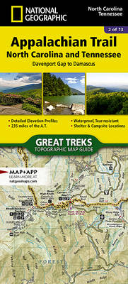
Appalachian Trail: Davenport Gap to Damascus Map [North Carolina, Tennessee]
Trails Illustrated
15,95 €
+ 31 points
Description
- Waterproof - Tear-Resistant - Topographic Map
The Davenport Gap to Damascus Topographic Map Guide makes a perfect traveling companion when traversing the northeastern Tennessee and western North Carolina section of the Appalachian Trail (A.T.). The A.T. in northeastern Tennessee and western North Carolina mostly follows a high, crooked ridgeline across the Southern Appalachians, an area that is known for both its natural beauty and rich history. This mountainous section of trail, which is mostly contained within the Cherokee and Pisgah National Forests, travels across the uplands of the Tennessee Valley, through the scenic Roan Highlands, and along the high ridge that separates Tennessee and North Carolina, deep in the heart of the Appalachian Mountain Range.
Each A.T. Topographic Map Guide includes detailed topographic maps at a detail of 1 inch = 1 mile. Each page is centered on the A.T. and overlaps with the adjacent pages so there is little chance of getting lost. Along the bottom of each page is a trail profile that shows the distance between shelters, camping areas, and trail access points. The map and trail profile provide a step by step visual guide to hiking the trail, mile by rugged mile. The Topographic Map Guide is built for all levels of hiking enthusiasts, from the day tripper to the multi month 'thru-hiker'. The front pages of the printed Topographic Map Guide include resupply information, town inset maps, camping options, and much more.
Every Topographic Map Guide is printed on "Backcountry Tough" waterproof, tear-resistant paper. A full UTM grid is printed on the map to aid with GPS navigation.
Other features found on this map include: Abingdon Gap Shelter, Bald Mountain Shelter, Big Bald, Cherokee National Forest, Cherry Gap Shelter, Clyde Smith Shelter, Cosby Knob Shelter, Curley Maple Gap Shelter, Damascus, Davenport Gap Shelter, Deer Park Mountain Shelter, Double Springs Shelter, Erwin, Flint Mountain Shelter, Groundhog Creek Shelter, Hogback Ridge Shelter, Hot Springs, Iron Mountain Shelter, Jerry Cabin Shelter, Laurel Fork Gorge, Laurel Fork Shelter, Little Laurel Shelter, Max Patch Mountain, Moreland Gap Shelter, Mountaineer Shelter, No Business Knob Shelter, Overmountain Shelter, Pisgah National Forest, Roan High Knob Shelter, Roaring Fork Shelter, Saunders Shelter, Spring Mountain Shelter, Stan Murray Shelter, Vandeventer Shelter, Walnut Mountain Shelter, Watauga Lake Shelter.
- Map Scale = 1:63,360
- Folded Size = 4.25" x 9.25"
Spécifications
Parties prenantes
- Auteur(s) :
- Editeur:
Contenu
- Nombre de pages :
- 48
- Langue:
- Anglais
- Collection :
- Tome:
- n° 1502
Caractéristiques
- EAN:
- 9781597756396
- Date de parution :
- 22-12-15
- Format:
- Autre carte
- Format numérique:
- Gelamineerd
- Dimensions :
- 107 mm x 234 mm
- Poids :
- 90 g


Seulement chez Librairie Club
+ 31 points sur votre carte client de Librairie Club

Les avis
Nous publions uniquement les avis qui respectent les conditions requises. Consultez nos conditions pour les avis.