
En raison d'une grève chez bpost, des retards de livraison peuvent survenir. Besoin de quelque chose en urgence ? Optez pour un retrait en magasin ou rendez-vous dans une Librairie Club à proximité.
- Retrait en 2 heures
- Assortiment impressionnant
- Paiement sécurisé
- Toujours un magasin près de chez vous


Description
- Waterproof - Tear-Resistant - Topographic Maps
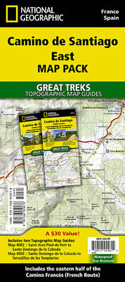
The Way of Saint James, known in Spanish as Camino de Santiago -- or simply El Camino (The Way) -- has been one of Europe's most iconic walking routes since 9th century pilgrims began making their way to the Cathedral of Santiago de Compostela to venerate the remains of Saint James. Though rooted in Christian tradition, the route has been reborn as a nondenominational spiritual rite and epic long distance trail that runs along Roman roads, across mountains, and through picturesque countryside and historic towns.Each Camino de Santiago Topographic Map Guide includes detailed topographic maps of 2 cm = 1 km. Each page is centered on the trail and overlaps with the adjacent pages so there is little chance of getting lost. Along the bottom of each page is a trail profile that shows the distance between towns, rest houses, and trail access points. The map and trail profile provide a step by step visual guide to hiking the trail.
The Map Pack Bundle contains two maps and covers the eastern Camino Francés (French Way) from Saint-Jean-Pied-de-Port in France to Terradillos de los Templarios.
The Camino de Santiago East Map Pack includes:
- 4002:: Camino de Santiago 1 of 4 [Saint-Jean-Pied-de-Port to Santo Domingo de la Calzada]
- 4003:: Camino de Santiago 2 of 4 [Santo Domingo de la Calzada to Terradillos de los Templarios]
- Map Scale = 1:50,000
- Folded Size = 4.25" x 9.38"
Spécifications
Parties prenantes
- Auteur(s) :
- Editeur:
Contenu
- Nombre de pages :
- 96
- Langue:
- Anglais
- Collection :
Caractéristiques
- EAN:
- 9781566959278
- Date de parution :
- 01-04-2024
- Format:
- Carte pliée
- Dimensions :
- 108 mm x 238 mm
- Poids :
- 167 g


Seulement chez Librairie Club
+ 73 points sur votre carte client de Librairie Club
Cadeau


Les avis
Nous publions uniquement les avis qui respectent les conditions requises. Consultez nos conditions pour les avis.