- Retrait en 2 heures
- Assortiment impressionnant
- Paiement sécurisé
- Toujours un magasin près de chez vous
- Retrait gratuit dans votre magasin Club
- 7.000.0000 titres dans notre catalogue
- Payer en toute sécurité
- Toujours un magasin près de chez vous


Description
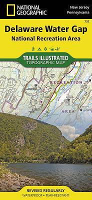
- Waterproof - Tear-Resistant - Topographic Map
Explore and discover new wonders with National Geographic's Trails Illustrated map of Delaware Water Gap National Recreation Area. Created in partnership with local land management agencies, this expertly researched map delivers unmatched detail and helpful information for paddlers, anglers, hikers, and other adventurers looking to explore the 70,000-acre park. The area's unique terrain, with low-forested mountains and 1,000-foot deep water gap, is the map's core feature, with detailed elevation contours, shaded relief, vegetation, and water features. Some of the key areas of interest included are Middle Delaware River; High Point, Swartswood, and Kittatinny Valley state parks; and Stillwater Natural Area.
With miles of mapped trails including portions of the Appalachian, Liberty Gap, and Joseph M. McDade trails, this map can guide you off the beaten path and back again. Trail mileage between intersections will help you choose the path that's right for you. River mileage and rapids on the Middle Delaware River are noted for those exploring by boat. Hiking, biking, and horse trails, along with major and secondary roads, are clearly distinguished. Boundaries for park lands, wilderness, and protected areas are color-coded and easy to discern. Some of the many recreation features shown include campgrounds, climbing areas, boat ramps, canoe access, and scenic areas. A trail chart and featured trails summary, as well as handy activity and waterfalls charts are included as well.
Every Trails Illustrated map is printed on "Backcountry Tough" waterproof, tear-resistant paper. A full UTM grid is printed on the map to aid with GPS navigation.
Other features found on this map include: Coolbaugh, Delaware Water Gap, East Stroudsburg, High Point, Kittatinny Mountain, Neversink River, Swartswood Lake.
- Map Scale = 1:40,000
- Sheet Size = 37.75" x 25.5"
- Folded Size = 4.25" x 9.25"
Spécifications
Parties prenantes
- Auteur(s) :
- Editeur:
Contenu
- Nombre de pages :
- 2
- Langue:
- Anglais
- Collection :
- Tome:
- n° 737
Caractéristiques
- EAN:
- 9781566956291
- Date de parution :
- 01-01-20
- Format:
- Carte pliée
- Dimensions :
- 229 mm x 104 mm
- Poids :
- 181 g


Seulement chez Librairie Club
+ 43 points sur votre carte client de Librairie Club
INSPIRATION


Les avis
Nous publions uniquement les avis qui respectent les conditions requises. Consultez nos conditions pour les avis.