
En raison d'une grève chez bpost, des retards de livraison peuvent survenir. Besoin de quelque chose en urgence ? Optez pour un retrait en magasin ou rendez-vous dans une Librairie Club à proximité.
- Retrait en 2 heures
- Assortiment impressionnant
- Paiement sécurisé
- Toujours un magasin près de chez vous


Description
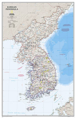
Amid increasingly combative rhetoric from Pyongyang, North Korea, do you know where its underground nuclear test site or missile launch centers are located? Are you aware that the South Korean government has begun a program to move its federal offices and personnel from Seoul to a new location? Expertly researched and designed, National Geographic's Korean Peninsula map provides this and much more information about this conflicted peninsula.
National Geographic Maps' Korean Peninsula wall map is one of the most authoritative maps of the Koreas. The peninsula's rugged terrain is expertly depicted in shaded relief, including the elevation of prominent mountains and ocean depths in meters. This edition clearly portrays both countries and uses the latest system for transcribing South Korean place-names from the Korean alphabet. In great detail, it delineates the latest administrative divisions of both countries along with the July 27, 1953 Military Demarcation Line--the historic demarcation line between the two Koreas. The map also portrays the transportation grid of both countries, including South Korea's high-speed passenger railway network.
The signature Classic style map uses a bright, easy to read color palette featuring blue oceans and stunning shaded relief that has been featured on National Geographic wall maps for over 75 years.
The map is packaged in a two inch diameter tube with a label showing a thumbnail of the map with dimensions and other pertinent information.
- Map Scale = 1:1,357,000
- Sheet Size = 23.25" x 35.75"
Spécifications
Parties prenantes
- Auteur(s) :
- Editeur:
Contenu
- Nombre de pages :
- 1
- Langue:
- Anglais
- Collection :
Caractéristiques
- EAN:
- 9781597755658
- Date de parution :
- 05-04-23
- Format:
- Carte roulée
- Dimensions :
- 59 cm x 91 cm
- Poids :
- 162 g


Seulement chez Librairie Club
+ 43 points sur votre carte client de Librairie Club
Cadeau


Les avis
Nous publions uniquement les avis qui respectent les conditions requises. Consultez nos conditions pour les avis.