
En raison d'une grève chez bpost, des retards de livraison peuvent survenir. Besoin de quelque chose en urgence ? Optez pour un retrait en magasin ou rendez-vous dans une Librairie Club à proximité.
- Retrait en 2 heures
- Assortiment impressionnant
- Paiement sécurisé
- Toujours un magasin près de chez vous


Description
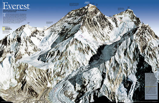
As seen in the May 2003 issue of National Geographic, this double-sided map celebrates the 50th anniversary of Sir Edmund Hillary's ascent to the summit of Mt. Everest. Side one features a digital rendering of Mount Everest created from infrared images taken by the space shuttle combined with stereo photographs taken from a jet aircraft. The work of generations of surveyors--stretching back to the days of George Everest himself--undergirds like bedrock this most detailed digital model of Mount Everest. The reverse side shows a map of Sagarmatha National Park and surrounding areas. Inset maps and informative sidebars describe the Sherpas, special locations in the area, the growth in visitors to the region, and the routes taken by famous Everest expeditions.
The map is packaged in a two inch diameter tube with a label showing a thumbnail of the map with dimensions and other pertinent information.
- Map Scale = 1:90,000
- Sheet Size = 31.25" x 20.25"
Spécifications
Parties prenantes
- Auteur(s) :
- Editeur:
Contenu
- Nombre de pages :
- 2
- Langue:
- Anglais
- Collection :
Caractéristiques
- EAN:
- 9780792249931
- Date de parution :
- 01-01-10
- Format:
- Carte roulée
- Dimensions :
- 119 cm x 77 cm
- Poids :
- 113 g


Seulement chez Librairie Club
+ 55 points sur votre carte client de Librairie Club
Cadeau


Les avis
Nous publions uniquement les avis qui respectent les conditions requises. Consultez nos conditions pour les avis.