
- Retrait en 2 heures
- Assortiment impressionnant
- Paiement sécurisé
- Toujours un magasin près de chez vous
- Retrait en 2 heures
- Assortiment impressionnant
- Paiement sécurisé
- Toujours un magasin près de chez vous


12,95 €
+ 25 points
Description
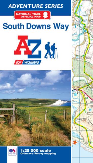
The A-Z Adventure Series of maps combines the best of OS and A-Z, creating the perfect companion for walkers, off-road cyclists, horse riders and anyone wishing to explore the great outdoors.The South Downs Way is a National Trail along the chalk escarpments and ridges of the South Downs. This undulating path begins in Winchester and finishes in Eastbourne covering 100 miles (160km) and lies completely within the South Downs National Park. The route on the map is clearly highlighted in yellow with mileage markers to gauge distances when planning sections of the walk to enjoy.This official National Trail Map* of the South Downs Way features 44 pages of continuous Ordnance Survey 1:25000 mapping providing complete coverage of the South Downs Way. This atlas includes a route planner showing distances between places and the amenities available, featuring: -Information Centres-Hotels/B&Bs-Youth Hostels-Campsites (seasonal opening)-Public Houses-Shops-Restaurants-Cafes (seasonal opening)-Petrol StationsAlso featured is advice on safety and security when walking and a selection of QR codes linked to useful websites, including temporary route updates from the National Trails, regional information, map reading advice and weather reports.Unlike the original OS sheets, this A-Z Adventure Atlas includes a comprehensive index to towns, villages, hamlets and locations, natural features, nature reserves, car parks and youth hostels, making it easy to find the required location quickly. Each index entry has a page reference and a six figure National Grid Reference. With a book size of 240mm x 134mm it is the same size as a standard folded OS map.Other National Trails available within the A-Z Adventure series include: Cotswold Way, Hadrian's Wall Path, North Downs Way, Offa's Dyke Path, Pembrokeshire Coast Path, Pennine Way, SW Coast Path, Thames Path and The Ridgeway.*A-Z is the official mapping partner of the National Trails.
Spécifications
Parties prenantes
- Auteur(s) :
- Editeur:
Contenu
- Nombre de pages :
- 60
- Langue:
- Anglais
- Collection :
Caractéristiques
- EAN:
- 9781782571674
- Date de parution :
- 20-07-18
- Format:
- Livre broché
- Format numérique:
- Trade paperback (VS)
- Dimensions :
- 134 mm x 240 mm
- Poids :
- 127 g


Seulement chez Librairie Club
+ 25 points sur votre carte client de Librairie Club
Cadeau


Les avis
Nous publions uniquement les avis qui respectent les conditions requises. Consultez nos conditions pour les avis.