
- Retrait en 2 heures
- Assortiment impressionnant
- Paiement sécurisé
- Toujours un magasin près de chez vous
- Retrait gratuit dans votre magasin Club
- 7.000.0000 titres dans notre catalogue
- Payer en toute sécurité
- Toujours un magasin près de chez vous


Description
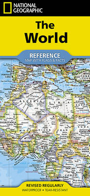
Expertly researched and designed, National Geographic's World with Flags & Facts Map is the authoritative map of the world by which other reference maps are measured. The folded world map is designed for travel and durability.
Product Features:
- Signature Classic style map with bright, easy to read color palette with blue oceans and colorful borders
- Background shows mountain ranges and valleys in subtle shaded relief with mountain ranges labeled
- Major water bodies including rivers, lakes, glaciers, oceans, seas, gulfs, bays, straits, and bathymetry
- Clearly defined international boundaries, cities, islands, airports, and physical features
- Thousands of place names carefully and artfully placed to maintain legibility in heavily populated areas
- Up-to-date international boundaries and territorial control reflect de facto status on the ground
- Meticulously researched using multiple authoritative sources including the U.N., U.S. Board on Geographic Names, and policies of individual governments.
- Accurate place names use a combination of conventional English names, official national names, and standard transliterations for non-Latin alphabets.
- Drawn in Winkel Tripel projection with distortions minimized unlike other World maps (e.g. Greenland is shown the same size as Argentina, not South America)
- Corner inset maps feature vegetation, land use, population density, and north and south polar regions
- National facts and flags with each country's area, population, capital city, GDP per capita, and flag
- Map Scale = 1:37,213,000
- Sheet Size = 37.75" x 25.5"
- Folded Size = 4.25" x 9.25"
Spécifications
Parties prenantes
- Auteur(s) :
- Editeur:
Contenu
- Nombre de pages :
- 2
- Langue:
- Anglais
- Collection :
Caractéristiques
- EAN:
- 9781566958080
- Date de parution :
- 01-12-23
- Format:
- Carte pliée
- Format numérique:
- Gelamineerd
- Dimensions :
- 11 cm x 24 cm
- Poids :
- 95 g


Seulement chez Librairie Club
+ 31 points sur votre carte client de Librairie Club

Les avis
Nous publions uniquement les avis qui respectent les conditions requises. Consultez nos conditions pour les avis.