
- Retrait en 2 heures
- Assortiment impressionnant
- Paiement sécurisé
- Toujours un magasin près de chez vous
- Retrait gratuit dans votre magasin Club
- 7.000.0000 titres dans notre catalogue
- Payer en toute sécurité
- Toujours un magasin près de chez vous


Description
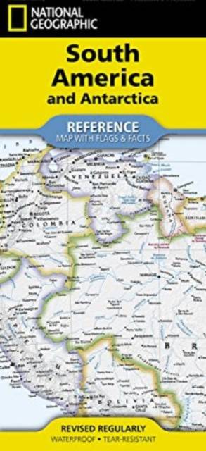
- Waterproof - Tear-Resistant - Reference Map
Expertly researched and designed, National Geographic's South America and Antarctica Flags & Facts Map is the authoritative map of South America by which other reference maps are measured. The map side includeds a political map showing countries, cities and other landmarks and a physical map shows the landforms such as mountain ranges and rivers. The Flags & Facts side includes a combined political and physical map of Antarctica.
- Clearly defined boundaries, major cities, and physical features
- Hundreds of place names carefully placed to maintain legibility in heavily populated areas
- Includes South America and Antarctica and adjacent regions within North America
- Detailed physical map of South America with mountain ranges, plains, lakes, and rivers
- Flags and facts with detailed information about cultural and physcial attributes
- Printed in the U.S.A. on extremely durable, waterproof, and tear-resistant material
This Reference Map is printed on durable synthetic paper, making it waterproof, tear-resistant and tough -- capable of withstanding the rigors of any kind of use in the home or classroom.
- Sheet Size = 18.5" x 25.25"
- Folded Size = 4.25" x 9.25"
Spécifications
Parties prenantes
- Auteur(s) :
- Editeur:
Contenu
- Nombre de pages :
- 2
- Langue:
- Anglais
- Collection :
Caractéristiques
- EAN:
- 9781566959346
- Date de parution :
- 01-12-22
- Format:
- Carte pliée
- Format numérique:
- Gelamineerd
- Dimensions :
- 11 cm x 24 cm
- Poids :
- 45 g


Seulement chez Librairie Club
+ 31 points sur votre carte client de Librairie Club

Les avis
Nous publions uniquement les avis qui respectent les conditions requises. Consultez nos conditions pour les avis.